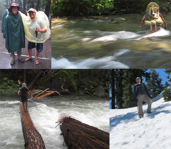
Our adventure began in the heavy rain of late June. We waved farewell to Allison from the Canyon Creek Trailhead to walk the Bigfoot Trail–in search of wild plants and places–for two weeks. As we climbed into the Trinity Alps it was doubtful we would be able to hike very far because of heavy snow and high water. On our second day, as the rain cleared, we approached the dangerously swift Stuarts Fork and were, for a moment, stopped by Mountains and Water.
Wet weather, heavy snow at the passes, and swift creek crossing typified the first week of hiking through the Trinity Alps, Russian Wilderness, and Marble Mountains. Bottom left is the crossing of Stuarts Fork in the Alps–without that log, the trip would not have happened.
Sequoia National Park & Monument • Original Publication DATE: 6/10/2011
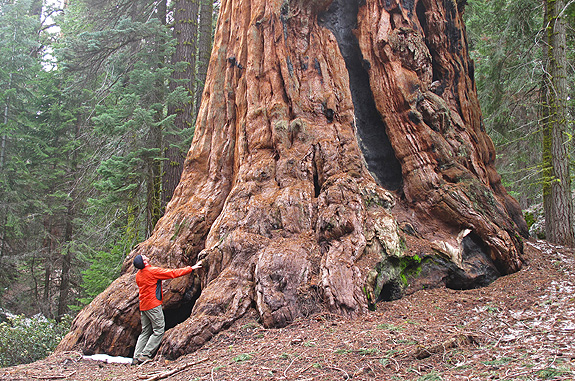
Sequoia National Monument – In search of giant sequoia (Sequoiadendron gigantium)
A slow return north from Mexico found me revisiting old stomping grounds in the southern Sierra Nevada. I first drove from Kernville to Springville to fully enjoy the Giant Sequoia National Monument. When I first ventured out on my own after college I lived near Springville and taught environmental education at SCICON. On weekends I would often attend church in the Freeman Creek grove, disappearing for hours on end in one of the largest stands of sequoias outside the national parks. I returned to this grove to re-explore 15 years after my first visits–I think the trees have gotten bigger.
This mountain range had been a place in my dreams for many years. I had heard about its rich conifer forest, that many of the conifers (and other plants of course) common within California reached their southern range extension here, and that a natural fire regime had been ‘maintained’ by mother nature. This was an intact a forest–in as natural a state–as we 21st century explorers might hope to find. The mountains themselves are part of the Peninsular Ranges which I was quite familiar with, having lived in the San Gabriel’s for many years.
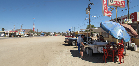
Fueling up on tacos in San Vicente before powering into the wilderness of Baja California Norte.
On the way to Huntington Beach to pick up a friend, I made a stop to see the northern most stand of Tecate cypress (Cupressus forbesii) in North America. It is an interesting place to visit because it was almost lost to development, but in the courts it was decided that the last wildlife corridor from the Santa Ana Mountains to the Chino Hills was more important than a new neighborhood. The cypresses are protected now in the Coal Canyon Ecological Preserve which is part of Chino Hills State Park. While the area is well studied the trees are difficult for the public to access–at least I could find little about getting to them. There were many bikers in the area, some of whom said the trees were more easily accessed from a different route than I took.
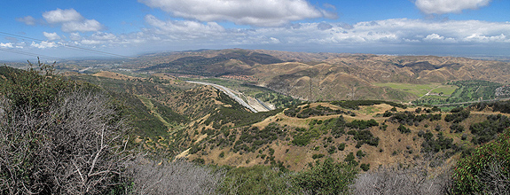
The highway and underpass between Coal Canyon (left) and the Chino Hills State Park (right).
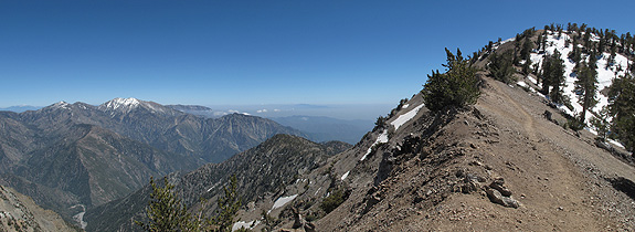
On the way south I decided to revisit some of my favorite hikes from when I lived in the San Gabriel Mountains and taught outdoor education. The top on the list was the summit of Mount Baden Powell. Because the summit is 9,399 feet, it is within close proximity of the Pacific Ocean (on the rare smog-free day it is visible), and on the edge of the Mojave Desert there is astounding plant diversity meeting and mixing on the flanks of the mountain. Day one of my journey I climbed the peak and day two I dropped into the San Gabriel River valley within the Sheep Mountain Wilderness to enjoy the lower elevations of Baden Powell’s mastiff. Both were amazing hikes–pictures follow.
The Ascent – Mount Baden Powell
The Pacific Crest Trail skirts the ridge and takes in the dramatic views on Baden Powell–the inverted layer of smog above the Los Angeles basin is also visible.
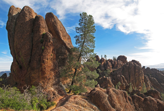
Day two of the journey to Mexico found a stop at the Pinnacles National Monument. I can’t believe I had never been there before–especially since I have thought about it often. It is the poster child for the land of the ghost pine in my mind because of a photograph taken here which appeared in Ron Lanner’s Conifers of California. In addition to the plants, I got up close and personal with Condor 99–a juvenile who was quite photogenic perched in a ghost pine. This was particularly exciting because I had spent so much time in the late ’90’s looking for condors in the Sespe and Sisquoc Wilderness areas but had never yet seen one. I finally got my glimpse. Later in the day I was driving through the Bitter Creek National Wildlife Refuge along the Cerro Noroeste Road and got to see a bird on the nest, incubating an egg. I was cued into this because a scientist was monitoring the nest from the San Diego Zoo. The condor return is an amazing success story.
The high route through the Pinnacles National Monument.
The first journey of the summer has begun and as I make my way south to the Sierra San Pedro Martir botanically diverse destinations will craft the route I drive. The first stop was not too far from home, but a place I had not yet been. The serpentine soils along the Frenzel Creek Research Natural Area foster the sympatric overlap of two cypresses–along with many other unique serpentine plants. Enjoy the photo-blog, as I won’t have a lot of time to write with many miles to travel.
MacNab cypress grow in a shrubby form in the uplands growing with leather oak among other species.
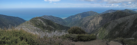
The Lost Coast presents plant associations (or lack of associates) that have long puzzled botanists. From the perspective of the conifer lover the question is: Why are redwoods, grand fir, and sitka spruce absent in an area which annually receives 100+ inches of rain, has some summer fog, and is nourished by soils from that of the central belt of the Franciscan Complex? These same conditions exist only a few mile north where redwood, grand fir, and Sitka spruce forests thrive. In the heart of this wilderness, over 20+ miles of walking, I found only two conifers. After and mentally and physically taxing journey I was left with a sense of wonder at the fortitude of the species that were present; and not the absence of the conifers unable to reside.
Panorama from King’s Peak where fire and life intertwine–where mixed-evergreen forest and coastal chaparral meet.
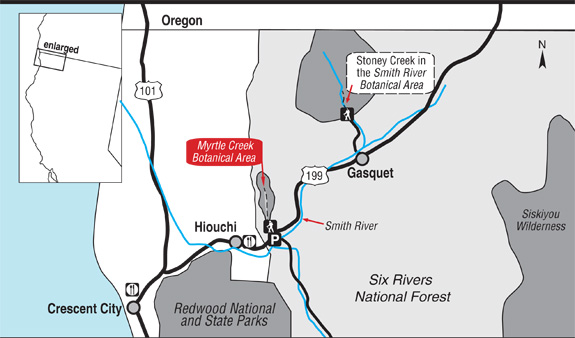
Situated on the border of two major rock types, Myrtle Creek Botanical Area is floristically challenging as well as aesthetically arousing due to this unique geological architecture. Along the western slopes of the Myrtle Creek drainage, the North Coast Range meets the Klamath Mountains against an ancient island-arc accretion known as the Josephine Ophiolite. Plant communities are often defined by rock type, and this juncture creates unique plant assemblages. It is a place where complex rock interacts–nutrient rich soils of Coast Range meets the nutrient poor serpentines of the Josephine Ophiolite. It is also a place where ample rain falls, often in the amount of 100 inches per year. Because of these complex abiotic interactions, plants touch roots with plants in associations that almost never occur. For example, redwoods (Sequoia sempervirens) grow with pitcher plants (Darlingtonia californica) and western redcedars (Thuja plicata) with knobcone pines (Pinus attenuata).
Historically, the drainage saw major mining operations transform the landscape when placer mining (panning) in the late 1800’s gave way to the more destructive–and potentially more lucrative–hydraulic mining during the early 1900’s. Eventually, all the accessible gold was removed and as the miners left the landscape, it slowly recovered. Today, all that remains from the operations is a major sluice where the trail begins, a ditch upon which the trail is built as well as several old shafts that are fenced in for protection.
The plants have returned and, with a few exceptions, are flourishing. The wildflowers begin in mid-March and continue into early June. Orchids, trilliums, azaleas, rhododendrons, mustards, buttercups, sorrels, wood roses, huckleberry, and more create a rare botanical legacy of unique associations–ready for exploration and self-discovery. Located within the Smith River National Recreation Area, the trail has interpretive signs to aid your discoveries along the 1+ miles to the creek.
Map to Myrtle Creek Botanical Area in the Six Rivers National Forest.
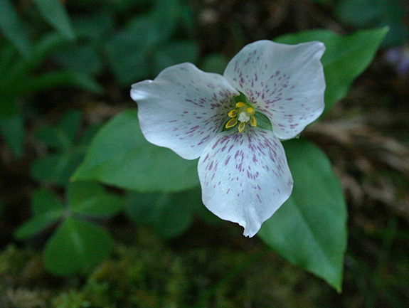
Brook wakerobin (Pseudotrillium rivale)
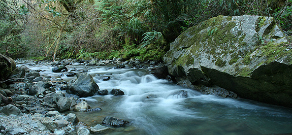
Myrtle Creek
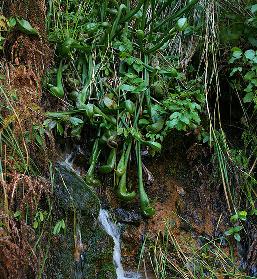
Darlingtonia californica (by Allison Poklemba)
Pictured above is California pitcher plant (Darlingtonia californica) growing on serpentine, which is not unusual in Del Norte County. What is unusual is that along Myrtle Creek it associates with salal (Gaultheria shallon) which is in the picture and growing just above–casting shade–is a redwood tree.
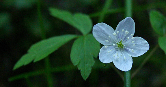
Anemone quinquefolia
Other Resources:
North Coast CNPS Page for Myrtle Creek Botanical Area
—– COMMENT: AUTHOR: Sue DATE: 4/24/2014 4:18:08 PM You said: “… a ditch upon which the trail is built…” This was no ditch, but a carefully constructed Chinese Footpath – the kind a person would see in Vietnam, Cambodia, Laos, or other Asian rainforest areas. In addition to a mining camp was a Chinese labor camp. They built the footpath – which used to extend from near the falls to what is now hwy 199. I have taken several Vietnam Veterans on this trail, and they are all amazed at the similarity between this “ditch” (as you call it) and trails they saw while in Vietnam. These Chinese trails are noted by drainage area on the ‘mountain’ side of the trail, and a berm on the “creek” side of the trail. This construction helps keep the trail intact despite wet weather. Unfortunately, after over 150 years, there have been some serious mudslides along the creek that covered portions of the footpath – making it very difficult to get to the falls. There are still gold mining claims along the creek, and in the past, these mining claims have been protected with rifles. But not any more. I love this creek, have hiked it for 40 years, and treasure the botanical life. But a well-maintained trail would be nice. I would love to be able to hike to the falls again on a real trail.
Sue- Thanks for the comment. Sounds like you have a great understanding and appreciation for this wonderful creek canyon. I am sorry if I offended you by calling it a ditch, I know better now! -Michael
Late in the summer of 2009 I re-visited an isolated population of junipers in the Yolla Bolly-Middle Eel Wilderness. The visit was inspired by Robert Adams after he read a blog post of my first visit to the trees. At the time, the population was believed to be Juniperus grandis based on habitat type and other morphological characteristics. After collecting the specimens and sending them to Baylor University for study Dr. Adams published two papers last month on these populations and their relationship to other junipers of the west. He graciously named me as a co-author for my collecting and final editing skills–otherwise the work was all his.
While the DNA and essential oil comparisons verified the Yolla Bolly junipers are Juniper occidentalis they did not clarify the relationship of Juniperus occidentalis to Juniperus grandis. Unusual similarities were found between occidentalis populations of Oregon and Northern California and grandis populations of the San Bernardino Mountains. As Dr. Adams states in his conclusions, some questions were answered with the research but more questions remain–further study is needed.
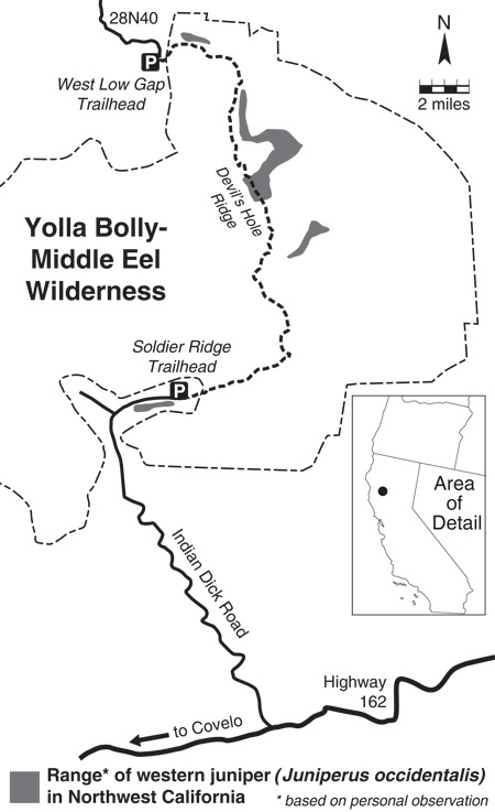
I created this range map after visiting the Yolla Bolly and observing several new, undocumented populations.
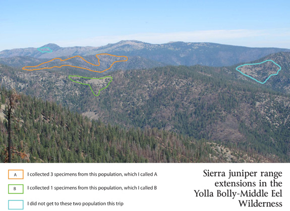
As viewed from the ridgeline west of Mount Linn looking northward the populations of western juniper generally grow just east of the ridgelines on sandy soil. Notice the image names the trees as Sierra juniper, which Dr. Adams proved to be wrong.
—–
COMMENT:
AUTHOR: Jeffrey Kane
DATE: 9/6/2010 12:36:05 AM
yo dude. congrats on the pub(s).
—–
COMMENT:
AUTHOR: Dewey Robbins
DATE: 5/24/2014 5:10:10 PM
This population extends from Low Gap southwesterly along Jones Ridge nearly to Hayden Roughs as isolated individual. Most of the trees my forestry crew and I found were young regeneration; however, there are a few gnarled fire-scarred relics that are more like shrubs than trees.
—–
COMMENT:
AUTHOR: Michael E Kauffmann
DATE: 5/26/2014 2:58:05 PM
Dewey– thanks for the note. I’ve never been to that area of the Yolla-Bolly, but want to get there. It looks like they extend even further west to the Eaton Roughs. It is private property, but I’d love to get there too.
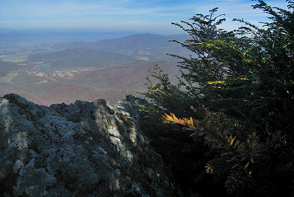
Botanists and ecologists familiar with the Klamath Mountains are inevitably familiar with the similarities the area has with the southern Appalachian Mountains. It is understood that both regions harbor exceptional plant diversity due to the complex interaction of several factors. They are each ancient mountain ranges that have sustained a similar flora since at least the Cenozoic. These mountainous regions have served as monadnocks–ultimately refuges for plants as populations of species have been eliminated by glaciation and climatic dessication1. Arriving in Virginia in a warm, dry November spell the Blue Ridge Mountains were beckoning me to visit as I peered toward them from the Shenandoah Valley.
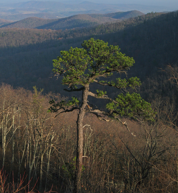
I decided to research a mountain top hike that would provide both views and of course–if possible–relict conifers. After finding a publication from 1966 about the conifers of Shenandoah National Park2 mom, dad, and I settled on Stony Man Mountain–the second highest peak in the park at 4010 feet. The Appalachians have an ancient history, being one of the oldest mountain ranges in the world. Stony Man’s summit is composed of greenstones–which were formed 800 million years ago (Ma) by lava flow. With time the rocks changed and were ultimately uplifted 200 Ma and have eroded back to their current height over millenia. The botanical interests–while dependant on the mountain for safe harbor–are a more recent circumstance.
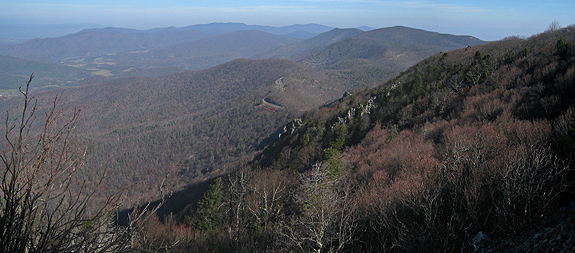
Looking northward along the Blue Ridge Mountains–Skyline Drive brought us to within a mile of the summit of Stony Man Mountain..
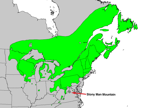
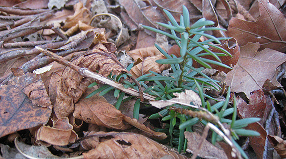
In addition to the wide array of flowering trees, shrubs and annuals that can be found in the Appalachians, several relict conifers survive on this particular mountain top and sporadically elsewhere across the rolling landscape. The conifers are harbingers for the microsites fostered by complex climate and geology which ultimately mimic conditions of a colder time. Canada yew (Taxus canadensis), red spruce (Picea rubens), and balsam fir (Abies balsamea) are found at their southern range extensions in and around the southern Appalachians of Virginia. These trees thrived in the colder climate of the Pleistocene but are now restricted to the highest mountain tops and coolest glades.
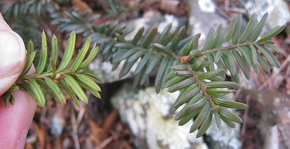
Canada Yew | Taxus canadensis
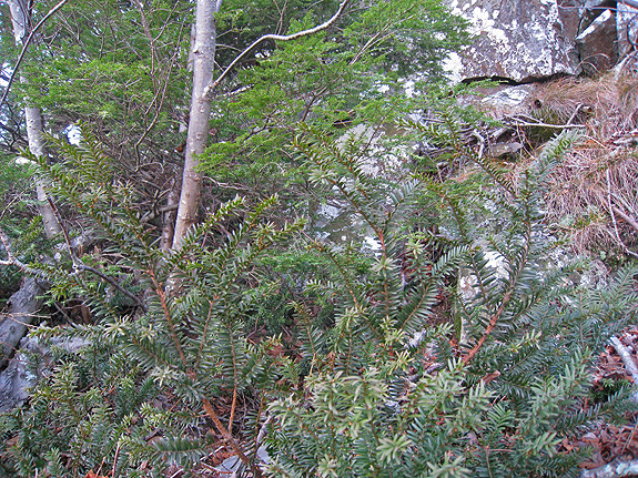
The Canada yew is an understory tree of late successional forests. This is exactly the habitat in which we found it in Shenandoah National Park. This yew of the northeast is ecologically identical to the Pacific yew (Taxus brevifolia) of the Pacific northwest. The small isolated population we found on the summit of Stony Man reminded me of select mountain tops of the Klamath–like Preston Peak. The population here was matted to the earth and often growing beneath and around shrubs on rocky outcrops punished by the elements.
Canada yew (Taxus canadensis) hangs from a rocky, north-facing cliff on Stony Man Mountain.
Taken from Digital Representations of Tree Species Range Maps from “Atlas of United States Trees” by Elbert L. Little, Jr.
Shrubs to 2 m, usually monoecious, low, diffusely branched, straggling, spreading to prostrate. Bark reddish, very thin. Branches spreading and ascending. Leaves 1-2.5 cm, pale green abaxially, dark green to yellow-green adaxially. Seed somewhat flattened, 4-5 mm. Seeds maturing late summer – early fall when present (3).
In the foreground Canada yew contrasts its yellow-green foliage to that of Tsuga canadensis in the background.
Canada yew is apparently shade tolerant and appears to reproduce vegetatively by spreading slow and low through the duff.
Needless to say, this was an exciting plant to find and learn about...as were those that follow but are discussed in less detail.
A few other conifer highlights included…
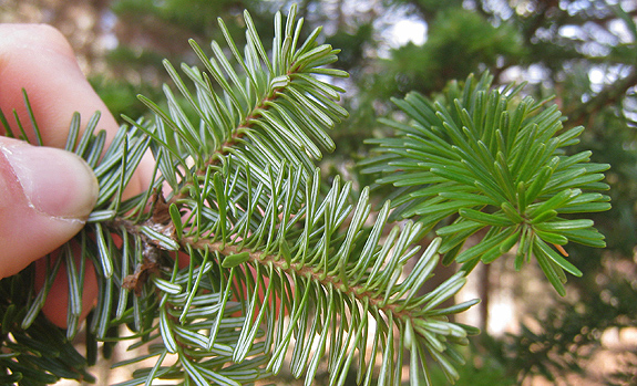
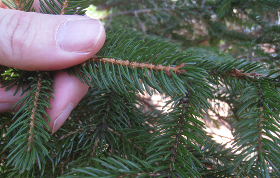
Balsam fir | Abies balsamea
Pictured here are needles from a Balsam fir on Stony Man Mountain. Farjon (1990) suggests that where ranges overlap between Frasier and balsam in Virginia that the hybrids are distinguished by small seed cones with exserted bracts much smaller than those of A. fraseri (5). We found no cones on this late November day.
Hils, Matthew H. 1993. Taxaceae. Flora of North America Editorial Committee (eds.): Flora of North America North of Mexico, Vol. 2. Oxford University Press.
Potter, K.M. et al. 2010. Evolutionary history of two endemic Appalachian conifers revealed using microsattilite markers. Conversation genetics. 11:1499-1513.
Farjon, Aljos. 1990. Pinaceae: drawings and descriptions of the genera Abies, Cedrus, Pseudolarix, Keteleeria, Nothotsuga, Tsuga, Cathaya, Pseudotsuga, Larix and Picea. Königstein: Koeltz Scientific Books
COMMENT:
AUTHOR: David Fix
DATE: 11/24/2010 2:17:02 PM
Thank you, Michael, for the quick look-see. Jude and I were in the park, as well as over in the Alleghenies in May and also enjoyed Red Spruce. It was fun to see you apply your landscape-parsing and plant skills to a different place. Question. What is that abundant and delicate knee-high fern with the pinnae that barely clasp your fingers as you feel it? But I simply enjoyed it in many spots and don’t need the name…
—–
COMMENT:
AUTHOR: Allison
DATE: 11/24/2010 2:43:10 PM
Great trip, beautiful! This also taught me that monadnock is not just a mountain in southern New Hampshire, but rather my favorite mountain is the name sake for the topographical phenomenon.
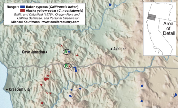
With the threat of our second significant storm of the season looming, I packed the truck and headed into a mysterious and isolated region of the Siskiyou Mountains to find two rare groves of trees and enjoy the transition toward winter. The roads are long and lonely leading south from Oregon’s Applegate Valley into the high peaks of extreme southern Oregon and northern California. This region drains the headwaters of the Applegate River where nebulous state borders are crisscrossed by wild mountains, rivers, and the occasional road. This is surely the quintessential ancient meeting ground where rare plants have hidden out for millenia–optimal environmental conditions are fostered with a unique balance of sun, soil, and water. In addition to the rare conifers under discussion one might also encounter Pacific silver-fir, subalpine fir , Brewer spruce, and Port Orford-cedar close by–not to mention the other more common species.
This map shows the only region in the world where the northern-most native cypress (C. bakeri) overlaps with Alaska yellow-cedar (C. nootkatensis) in its southern range extension.
One quick side note with respect to the genera I present here (without getting overly detailed)–several classification schemes currently exist for these species. Alaska-cedars have been placed in one of five genera by various sources: Cupressus, Chamaecyparis, Xanthocyparis, Hesperocyparis, and Callitropsis. Needless to say, things are a bit up in the air. While these names have yet to be worked out what has transpired, for now, is one of three scenerios:
“We need wilderness because we are wild animals. Every man needs a place where he can go to go crazy in peace. Every Boy Scout troop deserves a forest to get lost, miserable, and starving in. Even the maddest murderer of the sweetest wife should get a chance for a run to the sanctuary of the hills. If only for the sport of it. For the terror, freedom, and delirium…” – Edward Abbey,from The Journey Home
With the passing of the Northern California Coastal Wild Heritage Act in 2006 over 150,000 acres of new wilderness areas were added to the wilderness preservation system. Those new areas are: Yuki, Sanhedrin, Mount Lassic, King Range, Cedar Roughs, Cache Creek , and South Fork of the Eel River. Most of these areas are administered by the Bureau of Land Management (BLM) and there is not much information out there about these places–including how to access our public lands. In many ways this is exciting–the journey to go “crazy in peace” is an ominous and difficult one–in many ways what wilderness should be. With new wilderness on my mind I drove the 70 miles south of Eureka, just into Mendocino County, in an attempt to see this new wilderness and the rare plant communities fostered in the edaphic sky island found there. Though interested in all plants, I must admit the driving force behind this trip was to see the northern range extension of Sargent cypress. Continue reading “South Fork Eel River Wilderness | Red Mountain Unit”
In 1969 Dale Thornburgh and John Sawyer discovered the first subalpine fir in California and also in the Klamath Mountains. This discovery was made in the vicinity of Russian Peak in what is now the Russian Wilderness. Since that time the species has been found in a total of eight locations in California’s Klamath Mountains and twice in Oregon’s Klamath. One of those Oregon locations is near Mt. Ashland and the other was recently discovered by Frank Callahan to the east in the Red Buttes Wilderness. This second location, in an isolated cirque on the north side of Tannen Peak was my destination–with Frank Callahan as my guide.Continue reading “Subalpine Fir in the Red Buttes Wilderness”
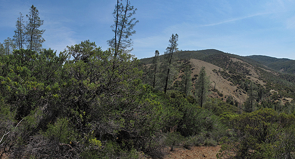
Mount Linn–also called South Yolla Bolly Mountain–is the highest point in the Coast Range of northern California. It is located to the west of Corning but the area might as well be a world away from the population centers of the state; it is rarely noticed by travelers as they drive Interstate 5. Once off the interstate, scenic forest service roads still take nearly 2 hours to wind to the trailhead. Although this place has always been on my list of places to visit–the impetus for this visit was to collect some samples of the rare Sierra juniper (Juniperus grandis) for Robert Adams of Baylor University so that, through DNA testing, he might find out if these trees truly are what we think they are (see previous blog). After a 25 mile sojourn deep into the wilderness to collect those specimens it was time to search for the southern most stand of foxtail pine in northwest California–on Mount Linn.
The distinct cones and “bottle-brush tassle” branches help to identify Pinus Balfouriana.
Two days into my 400 mile trek on the Bigfoot Trail I stopped to watch rain clouds clear above the headwaters of Cottonwood Creek–deep in the Yolla Bolly-Middle Eel Wilderness. As wind whipped the cool electric air past my ears a plant caught my eye–20 yards below the ridge on which I was balanced. This stately specimen had taken purchase many years ago in this rocky, windswept environment. This was a place in which only the heartiest of plants could hope to endure. Its reddish branches stood out in stark contrast to the lime green foliage. As I slowly crawled down the hillside my mind turned over and over with ideas of what species this might be. At first I believed it was cypress–possibly a MacNab or Sargent. But As I got closer I noticed the berry cones which are a diagnostic trait of junipers.
western juniper (Juniperus occidentalis) on a windswept ridge.
High above the headwaters of the Salmon River and Coffee Creek, the remarkable ascension of Packers Peak is surprising next to the seemingly superlative granite of the Alps. The peak is a pedestal on which to perch, understand, and enjoy the complex Trinity Alps Wilderness that surrounds you. It is a steep climb from Big Flat, at the end of Coffee Creek Road, to reach this vantage point; but if you are willing to climb the nearly 3,000 feet in just under 3 miles, you will be rewarded.
Atop Packers Peak, rock and plant fabulously frame the high Trinity Alps.