South Fork Eel River Wilderness | Red Mountain Unit
Original Publication DATE: 11/7/2010
“We need wilderness because we are wild animals. Every man needs a place where he can go to go crazy in peace. Every Boy Scout troop deserves a forest to get lost, miserable, and starving in. Even the maddest murderer of the sweetest wife should get a chance for a run to the sanctuary of the hills. If only for the sport of it. For the terror, freedom, and delirium…” – Edward Abbey,from The Journey Home
With the passing of the Northern California Coastal Wild Heritage Act in 2006 over 150,000 acres of new wilderness areas were added to the wilderness preservation system. Those new areas are: Yuki, Sanhedrin, Mount Lassic, King Range, Cedar Roughs, Cache Creek , and South Fork of the Eel River. Most of these areas are administered by the Bureau of Land Management (BLM) and there is not much information out there about these places–including how to access our public lands. In many ways this is exciting–the journey to go “crazy in peace” is an ominous and difficult one–in many ways what wilderness should be. With new wilderness on my mind I drove the 70 miles south of Eureka, just into Mendocino County, in an attempt to see this new wilderness and the rare plant communities fostered in the edaphic sky island found there. Though interested in all plants, I must admit the driving force behind this trip was to see the northern range extension of Sargent cypress.
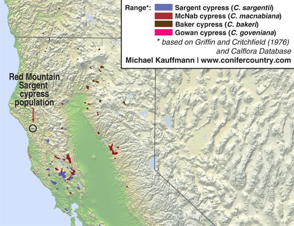
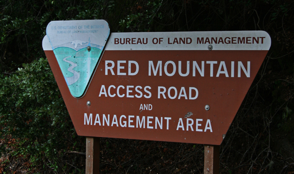
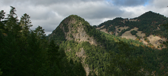
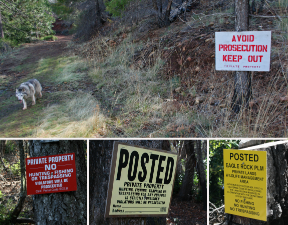
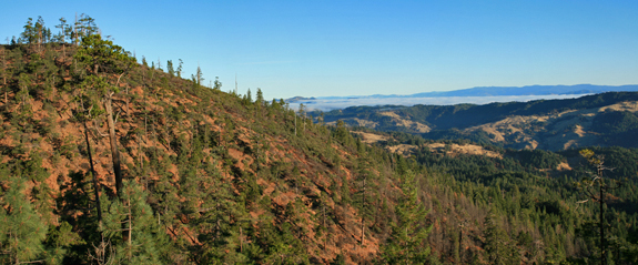
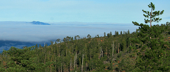
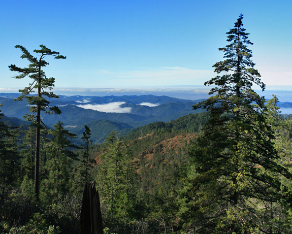
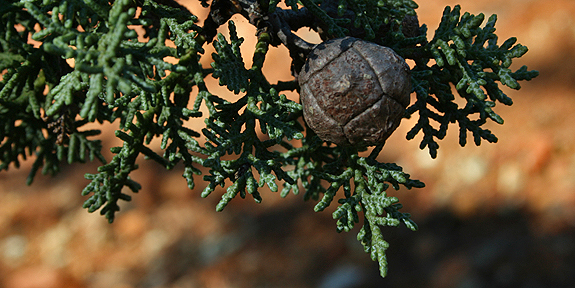
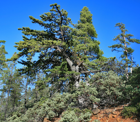
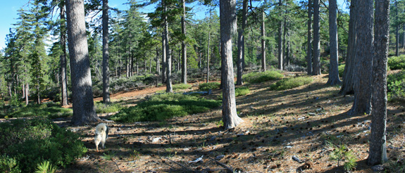
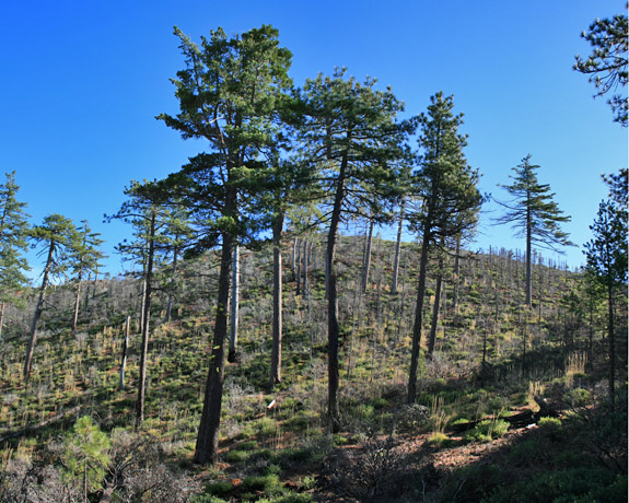
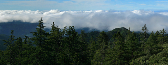
This map I created for cypress distribution in northern California shows Red Mountain and the northern range extension for the Sargent cypress as well as where one might encounter other cypresses in the region.4.7 miles south of the Mendocino/Humboldt County line exit Highway 101 and travel north on HWY 271 for 1/4 mile. Take the right at this sign and drive 14.5 miles (with 4WD) to roads end, where the adventure really begins .After 12 miles on Red Mountain Road, pass Noble Butte–a beacon above the East Branch of the South Fork Eel River.I do not believe that I ever trespassed to access the wilderness. When I encountered these signs I left the old roads on which I was walking and headed uphill, cross-country style. Ultimately zig-zagging my way up the mountain and onto our BLM public lands–I wonder how Skylar would have done in a court room had he been caught?With elevation came serpentine and rare plants. The mountains in the distance comprise the Yolla Bolly–Middle Eel Wildness.From the summit of Red Mountain sugar pines (Pinus lambertiana) were common–as they are on the summit of Kings Peak which is rising above the fog in the newly designated Kings Range Wilderness.After 3.5 hours of walking, I finally found the Sargent cypress. They were clustered in the steep headwaters of Cedar Creek.“Trees to 25 m, but often shrubby and less than 10 m; crown broader thantall or columnar, dense or open. Bark rough, furrowed, fibrous.Branchlets decussate, (1.5)2-2.5 mm diam. Leaves usually withinconspicuous, shallow, pitlike, abaxial gland that usually does notproduce drop of resin, often glaucous. Pollen cones mostly 3-4 × 2 mm;pollen sacs 3-4. Seed cones usually globose, mostly 2-2.5 cm, brown orgray, not glaucous; scales mostly 3-4 pairs, with scattered resinblisters, umbos inconspicuous or to 4 mm. Seeds 4-6 mm, dark brown,faintly to prominently glaucous”1Typical habitat for Sargent cypress–growing with Pinus attenuata, Pinus lambertiana, Pinus jeffreyi, Quercus vaccinifolia, Garrya congdonii, Rhamnus californica, and Arctostaphylos viscida.Typical Red Mountain north-facing forest composed of P. jeffreyi, P. lambertiana, C. decurrens with and understory of Q. vaccinifolia.The Red Mountain Fire moved through the area in 2005. I did not witness catastrophic destruction, only a clean, low intensity burn of the understory mainly along dry slopes and ridgelines in the eastern part of the mountain complex. The fire did not extend into the crowns of trees above 20m tall, leaving an open understory as seen here.As the clouds rolled in from the Pacific Ocean and silhouetted the Sargent cypress, I turned back and wondered when I might return to the South Fork Eel River
Resources:
1. Jennings, Greg. 2003. Rare-Plant Mapping on BLM Lands Red Mountain, Mendocino County. U.S. Fish and Wildlife Service.
2. USFWS Red Mountain buckwheat
3. USFWS Red Mountain sedum
4. South Fork Eel River at wilderness.net
5. Conifer Country resources for South Fork Eel River Wilderness (including a map of the region and Sargent cypress distribution)
Citations:
1. Eckenwalder, James E. 1993. Cupressus. Flora of North America EditorialCommittee (eds.): Flora of North America North of Mexico, Vol. 2. OxfordUniversity Press.
—–
COMMENT:
AUTHOR: Lauren Lester
DATE: 11/10/2010 3:41:18 AM Another good trip. I voted for prop 19 for same reasons- take back the wilderness! –Lauren Lester
Lauren- After some further research it turns out that those signs where posted more for the Mexican Cartels that have begun to show up recently and grow in the summer. Even scarier than the simple entitlement of local landowners. -Michael
—–
COMMENT:
AUTHOR: Red Mtn Ed
DATE: 4/16/2012 3:44:19 AM
Nice write up on Red Mtn. Michael Kauffmann.
Best route to top, 4084 ft, is up School Section Creek.
Full day workout … BLM seems to care.
One Reply to “South Fork Eel River Wilderness | Red Mountain Unit”
Hi Micheal,
I am long time fan of your work.
Institute for Sustainable Forestry is doing some field trips that you might be interested in. We are going to Red Mountain in the South Fork Eel Wilderness on June 16th. Then we are going to the Lassics on June 23rd. We would love to have you along. Email me back if you would like to get on the email list.
We have monthly trips to similarly interesting places for the rest of the year.
Tim