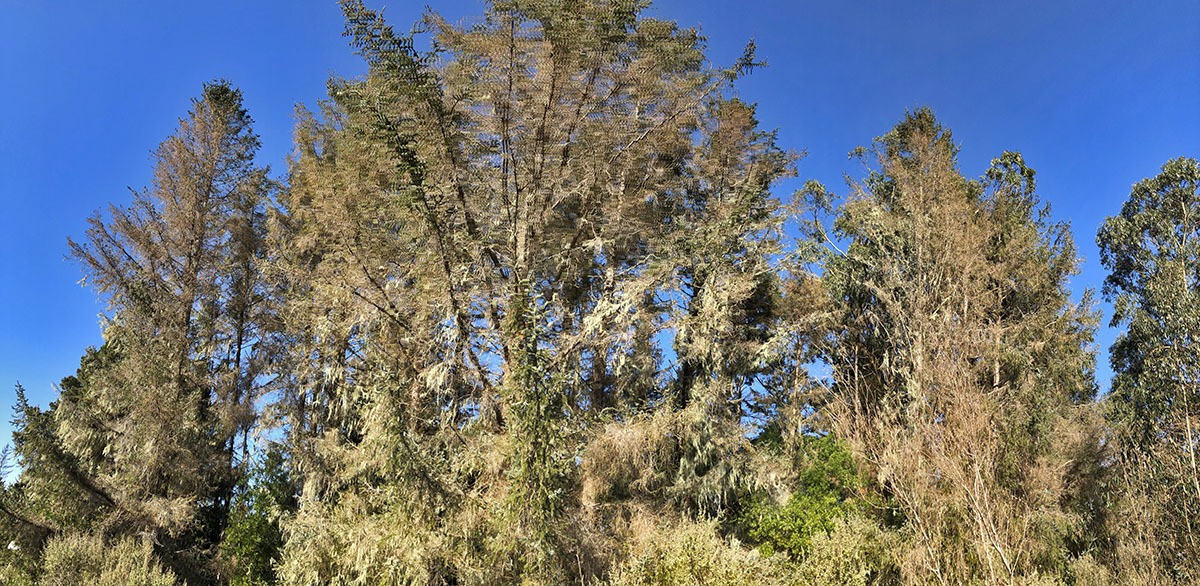
My other side of the Mountain

Exploring upper Copper and Indian creeks for yellow-cedar

I have been mapping and inventorying yellow-cedar (Callitropsis nootkatensis) in California for the past four years. This process could have been much more efficient if it wasn’t for the 2018 Eclipse Complex and the 2019 Natchez Fire (more below) that virtually closed the Siskiyou Wilderness for the past two summers.

Successful surveys before this year have doubled the previously known area of this rare conifer from approximately 5 hectares in 2015 to 11 hectares by 2018. One of the largest gaps in surveys was within upper Indian and Copper creeks in the Klamath River watershed. I predicted this is where the largest stands of the species would be–little did I know how large an area I would find.

Camping with yellow-cedar.
El Capitan (6670′) looms above Copper Creek.
Continue reading “My other side of the Mountain”

Redwood Experimental Forest

Exploring the Yurok RNA

Many years back I discovered that there were little known biodiversity hotspots that had been described by a handful of ecologists. These places had been designated as Research Natural Areas for the primary purposes of maintaining biological diversity, providing baseline ecological information, and encouraging research and university natural-history education. These places are all relatively pristine and sometimes close to roads in non-wilderness areas.

It was in this way that I first learned about the Redwood Experimental Forest that also contains the Yurok RNA. But I had never visited this place despite the fact it has been on my list since the early 2000s. That all changed in June 2019.

This team is embarking on a three year study of conifer resistance to drought. Our study will involve at least six species, both common and uncommon, across the Klamath Mountain region.
Continue reading “Redwood Experimental Forest”

Residual Old Growth

Big Trees of the Freshwater Creek Drainage, Humboldt County

Old-growth forests are forests that have developed over long periods of time, without experiencing severe, stand-replacing disturbance—a fire, windstorm, or logging. Within the redwood forest belt, of the estimated 1.6 million acres of redwood forest remaining, only 7% is old growth. The remaining 93% is considered some level of second growth. Around Humboldt Bay where we live that number is approaching 99%. The old-growth trees that do remain are often mixed within the second growth forests. Most often, an old tree was left behind by loggers because of imperfections like broken tops or less than optimal heartwood. This post explores some of the residual old growth in my neighborhood.

Continue reading “Residual Old Growth”

Northwest California Wilderness, Recreation, and Working Forests Act

In mid-September I had the opportunity to assist in guiding an EcoFlight across the North Coast and Klamath Mountains. I was invited by the California Wilderness Coalition to point out landmarks and important areas to Congressman Huffman’s staff and local media outlets as they relate to the Northwest California Wilderness, Recreation, and Working Forests Act. The following is a photo tour from the flight that highlights parts of the bill. If so inspired, please follow the links at the end to get involved!

Continue reading “Northwest California Wilderness, Recreation, and Working Forests Act”

Warner Mountains — whitebark pines and beyond

Warner Mountains
Conifers of the Warner Mountains. Maps from Conifers of the Pacific Slope.

The Warner Mountains are a north-south trending fault block range in the northeastern corner of California, extending northward into Oregon. The length of the range is approximately 90 miles, with the northern California portion bounded by Goose Lake on the west and Surprise Valley on the east. In California, elevations range between 5,000-9,897 feet (on Eagle Peak). In the High Grade district, which is the extreme northern limits of the Warners in California, the range has a fairly even crest of 7500 feet, reaching an elevation of 8290 feet on Mount Bidwell. This is the area where I spent four days mapping and monitoring whitebark pine (Pinus albicaulis) for the US Forest Service.

The geology of the region is complex and compelled me to understand it better. Bedrock consists of sedimentary rocks of the Oligocene overlain by rhyolitic to basaltic volcanic rocks of the Miocene. The basal andesite is overlain by rhyolite and glassy rhyolite, which are in turn overlain by basalt flows. There are valuable minerals and gems found in this area that have justified a long-standing history of mining. Gold was the first and major extracted mineral soon followed by opals, petrified wood, and even obsidian. The range is a complex assemblage of interesting rocks for sure which help sculpt the regional ecology.

The northern Warner Mountains have a long history of mining.

Continue reading “Warner Mountains — whitebark pines and beyond”