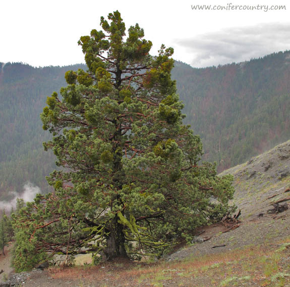
Two days into my 400 mile trek on the Bigfoot Trail I stopped to watch rain clouds clear above the headwaters of Cottonwood Creek–deep in the Yolla Bolly-Middle Eel Wilderness. As wind whipped the cool electric air past my ears a plant caught my eye–20 yards below the ridge on which I was balanced. This stately specimen had taken purchase many years ago in this rocky, windswept environment. This was a place in which only the heartiest of plants could hope to endure. Its reddish branches stood out in stark contrast to the lime green foliage. As I slowly crawled down the hillside my mind turned over and over with ideas of what species this might be. At first I believed it was cypress–possibly a MacNab or Sargent. But As I got closer I noticed the berry cones which are a diagnostic trait of junipers.
western juniper (Juniperus occidentalis) on a windswept ridge.
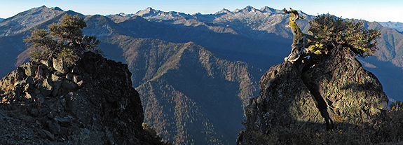
High above the headwaters of the Salmon River and Coffee Creek, the remarkable ascension of Packers Peak is surprising next to the seemingly superlative granite of the Alps. The peak is a pedestal on which to perch, understand, and enjoy the complex Trinity Alps Wilderness that surrounds you. It is a steep climb from Big Flat, at the end of Coffee Creek Road, to reach this vantage point; but if you are willing to climb the nearly 3,000 feet in just under 3 miles, you will be rewarded.
Atop Packers Peak, rock and plant fabulously frame the high Trinity Alps.
Gaining an understanding of geology and fire ecology
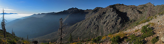
I had often pondered a high and extensive ridgeline in the middle of the Trinity Alps Wilderness from other mountain top vantage points on which I stood–at one point or another–in my adventures in the Klamath Mountains. It took me several years to realize this jagged range had its own name and many years more to actually get to this isolated place. Finally, in October, I climbed my way into the high country known as Limestone Ridge. I had read this extensive ridgeline (over 3 miles long) was one of the best examples of Karst topography in western North America. This summer, the spectacular Marble Mountain was my first introduction to Karst limestone landscape in the Klamath so I assiduously pursued a chance to see more. With those distant images and arresting words burned on my brain I was finally climbing–up–up–up–from Hobo Gulch in the Trinity River Canyon.
Climbing higher and higher, smoke lingers from this years fires while charred chaparral and montane forest remind the temporal visitor of previous year’s fires–leaving the gabbro pluton exposed, as if only just uplifted from the depths of the earth.
When John Sawyer and his wife Jane first invited Allison and I to join them on the Big Island for a few weeks, he issued a staunch warning when he said “Michael, there are no native conifers anywhere on the chain of Hawaiian Islands.” After some discussion with Allison I conceded that, even with the absence of conifers, this was an opportunity we could not miss. I was allowed to bring Farjon’s Conifers: A Natural History for some light reading on the beaches—otherwise we packed efficiently for the sub-tropics. John and Jane promised to bring all the plant books we could possibly need.
For the first few days plants were of secondary concern as we toured the beaches and snorkeled in underwater worlds I had never seen before. But eventually, we made our way into the high country, away from the beaches which were planted with, or invaded by, many non-native species. As we climbed the road to Mauna Kea, eventually into the alpine, we discussed plant distributions and origins on the islands as we peered far over the Pacific Ocean. Hawaii is one of the most isolated places on earth. The nearest land mass is another island chain called the Marquesas, which are 2,000 miles away, the west coast of North America is 2,400 miles, and Japan is 3,800 miles.
This volcanic chain of islands first started its fiery formation 80,000,000 years ago with the creation of Mejii, the western most island. Over time, at a rate of 3.5 inches per year, the plates shifted as lava continued to flow eventually establishing more than 80 islands spread over 3,800 miles. Mejii is now located—eroded and underwater—off the coast of Siberia’s Kamchatka Peninsula. The current western most island is Kure Atole which is 27 million years old and 1,600 miles from Honolulu (Walther). Kaua’i, the oldest of the eight main islands, is a mere 5 million years old. It is apparent, that on a grand scale, these islands form “fast” and die “fast.”
Having set the geological history straight, the big question for me became: How did the native plants get here? In the discussion that follows and in the research cited, native plants on Hawaii are described as pre-Polynesian plants—in other words, plants that have been here for tens of thousands of years that reached the islands without the aid of humans.
The cloud forests—above 5,000’—offered a rare Pacific refuge for certain plants carried here and already adapted to cooler climatic conditions. On Hawaii at elevation, and in similar habitat through the sub-tropics, Vaccinium spp. thrive.
In 1961, Fosberg found that 18% of Hawaiin native plants were from the Americas, 17% form Australia, 40% from the Indio-Pacific, 3% from the arctic and the rest are of unknown origin. In 1970, Carlquist’s examined seed origin and found that, in those 80 million years, 270 species of plants eventually gave rise to 1,060 native species on the islands—that equates to one successful speciation event every 296,000 years! (Walter). Carlquist went on to state that of these 270 pioneers 1.4% arrived by air, 23.8% by sea and 74.8% by bird. So with the right vessel for distribution and a comfortable landing in just the right habitat, plant life evolved.
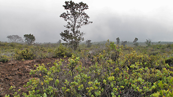
In our adventures around the Big Island Allison and I struggled to get comfortable with the plant families here—many of which were new to us. Over 60% percent of the plants here originated in the southern hemisphere, this was new botanical territory. We were definitely entertained by the newness, but it left us feeling like invasive species. We needed something to latch on to, to remind us of home—some sort of habitatual-home so-to-speak. As we climbed into the high country of Mauna Kea and Mauna Loa, particularly in the pristine native forests of Hawaii Volcanoes National Park, we recognized not only a family but a genus that we loved from the mainland.
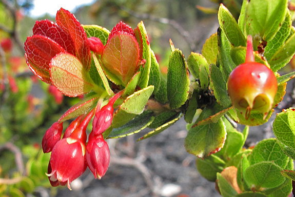
Fruits and berries of Vaccinium peleanum.
Ericaceae is a common family for anyone who has enjoyed a blueberry pie, pondered a Manzanita in California, or slathered huckleberry jam on toast. As a general rule plants from the genus Vaccinium have tasty berries that people take advantage of, especially in the temperate regions of North America, every fall. Here on the Big Island of Hawaii, there are three native species of Vaccinium (Hall) and possibly up to six on the entire chain. These species hail originally from the north temperate regions and were distributed—by (constipated?) aerial adventurers—between Pacific Island mountain tops from Hawaii to Fiji to Somoa (Kepler). Merlin goes as far to say that these species closest relatives are located in the forests of the Pacific Northwest—giving more foundation to the comfort level we had when finding these plants. We felt at home in the high elevations forests and sub-alpine landscapes where the Vaccinium thrived.
Vaccinium reticulatum, one of the Vaccinium ssp. to speciate from an ancient Pacific Northwest ancestor within the Hawaiian Islands, grows between 3,000 and 5,000 feet
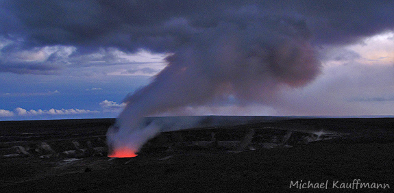
As on the mainland, Vaccinium were held sacred by native Hawaiians. They believed that ‘ohelo, was venerated by the Volcano God, Pele. Before consuming the berries themselves, they would offer branches bearing fruits to Pele by throwing them into the fiery cauldron of Kilauea (Lamoureux). Allison and I offered our love to the island (because we were not allowed near Kilauea) and the experiences offered to us by its kind people before consuming (sparingly) the plentiful fruit on several of our hikes in Hawaii Volcanoes National Park. After a wonderful two week visit, our comfort for landscapes on the island grew as well. We reluctantly departed, back to the frigid winter of the mainland, excited to return another time to learn more about this sub-tropical wonderland.
The cauldron in Kilauea Crater to which the native people would offer ‘ohelo to Pele, before enjoying the tasty berries themselves.
Resources:
1.Carlquist, S. 1970, Hawaii: A Natural History, Natural History Press, New York, New York.
2.Fosberg, F.R. 1961. Guide to Excursions III, Tenth Pacific Congress. University of Hawaii at Manoa, Honolulu, Hawai’i.
3.Hall, John B. 2004. A Hiker’s Guide to Trailside Plants in Hawaii. Mutual Publishing, Honolulu, Hawaii.
7.Walther, Michael, 2004. A Guide to Hawaii’s Coastal Plants, Mutual Publishing, Honolulu, Hawaii.
—– COMMENT: AUTHOR: Kandler Smith DATE: 12/25/2009 10:35:01 PM My botanogeek wife and I enjoyed reading about your travels! Sounds like a great trip. Merry Christmas! —– COMMENT: AUTHOR: David Fix DATE: 12/26/2009 7:02:05 AM Michael, thanks for the impressions. Jude and I also enjoyed veg in Kona, on Mauna Kea, and the south side of the Big Island last year. We did a tour with a guide named Garry who’s with Hawaii Forest & Trails. Didn’t know what to expect but it was really good, and we recommend him. While in the Hakalau NWR (protected and regenerated forest on ne. slope of Mauna Kea) we had an ohia lehua pointed out to us which was perhaps forty inches in diameter. Garry said that the ohia grow only millimeters per year (radially) at most after their youthful flush, and that this tree could have been a thousand years old. I stood there gazing at stout limbs where, quite likely, long-extinct birds such as the Hawaiian ‘O-‘O, Mamo, or Akialoa may have foraged. Spending minutes with this giant was the equivalent of seeing “the big Doug” on a nw. CA hike. As a birder, I listened to the songs of half a dozen native species–trills, whistles, and other semi-tropical utterances–and had to wonder what that forest chorus would have sounded like pre-Captain Cook+ with the extinct birds also chiming in.
// Speaking of big dougs, did you know there is a ~100″ dbh Douglas-fir along Hwy 101 in Del Norte Redwoods S.P. that is easily seen from the highway? Park at the entrance to Mill Creek CG and walk back south about a few hundred feet; the big boy stands west of the road about 75′ off it and is obvious. Aside from diameter it is not an especially heroic tree, but it’s the largest non-redwood I have seen in the park. Rave on. JOIN THE SPOTTED OWL PARTY. U.S. OUT OF NORTH AMERICA! NO FOR PRESIDENT IN 2012 / Fix
David- Thanks for your impressions as well. I loved the birds up high as well and longed for more. Hakalau NWR sounds like a can’t miss next time we hit the island.
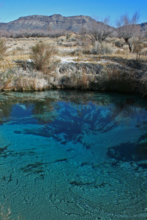
Ash Meadows National Wildlife Refuge is located along the eastern border of Death Valley National Park. The area presents an incredible juxtaposition to the desert — lush springs feed streams lined with riparian species; many of which are relicts of a wetter time. In this arid region, when precipitation befalls the mountains of southwestern Nevada, water percolates into aquifers. Over nearly a millennia this primordial water flows underground; forming the headwaters of the aboriginal Amargosa River. At Ash Meadows, these waters are forced up from the underground and a brilliant system of springs can be witnessed; in the heart of some of the most arid land on earth.
The velvet ash (Fraxinus velutina) for which the refuge is named
In wetter times of the Pleistocene the Amargosa River flowed here, connecting a system of lakes — all the way to the once-massive Lake Manly. This lake is now dry and known as Death Valley. As this system of rivers and lakes dried with time the fish became restricted to where water remained above ground. Today, Ash Meadows holds the bulk of these springs and hence — through speciation events due to geographical isolation — numerous species of pupfish. It is said that AMNWR has the greatest concentration of endemic life in the United States — at least 25 species have adapted to environments in and around the springs. Again, riparian relicts of and epoch gone by.
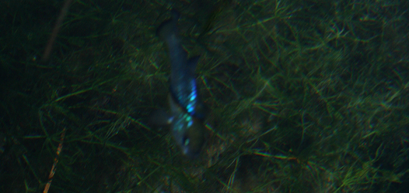
The Ash Meadows Amargosa pupfish (Cyprinodon nevadensis ssp. mionectes) thrive at Jackrabbit Springs.
The pupfish of the region behave as the cichlids of the African Great Lakes — being highly territorial and breeding in a around rocky shelves. Where as the African cichlids are an example of parapatric speciation, the pupfish of Ash Meadows exhibit allopatric speciation — because of their geographic isolation over time.
The region is still threatened. As water levels dropped to feed farms in the 1960’s, the level of water in the underground aquifer dropped and habitat for the Devil’s Hole pupfish (Cyprinodon diabolis) began to disappear. A Supreme Court ruling in 1976 limited the pumping of water and, for now, has saved this species — as the water remains at a level necessary for breeding near a prefered limestone shelf. The Devil’s Hole pupfish, because it lives in only one place — a litteral rock-hole-spring in the middle of the desert — is possibly the most environmentally restricted species on Earth. This area needs us to visit, to foster our understanding of the unique biota living on our planet.
The swirling emerald-blue water of Crystal Spring.