pərmyo͝oˈtāSH(ə)n
The action of changing the arrangement, especially the linear order, of a set of items (what came first, the conifer or the cone?)
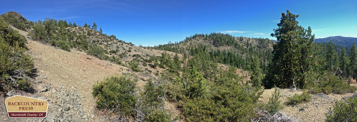
Wandering Devil’s Hole Ridge, miles from anything human, the landscape shifts as quickly as the juncos dancing across the trail. Walkabouts bring a level of focus not found in civilization. Walking offers time to hypothesize about the world at a slower pace…How recently did the vegetation patterns I see come to be? When did the Ash-throated flycatcher arrive from its tropical winter-land? How did I find myself in this desolate, isolated place–seven years after I last visited–and so far from my family? Like the undulating contours on the ridgeline, I ponder my place in this dynamic world. Walking further I realize, while out of place, I am fortunate to be here with time to think.
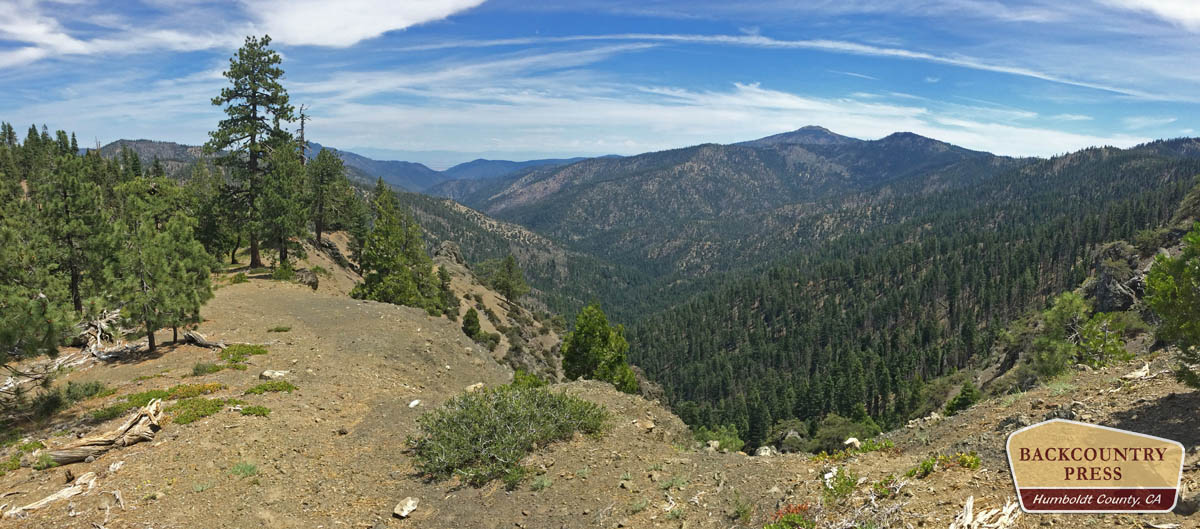
Seeing the trees through the forests, the birds in those trees, and then this vast landscape through my astigmatized-wide-angle glasses; thoughts swirl through my mind. The first few hours allow time to come to terms with my isolation and my body’s age (I’m moving slower than when I was here in my 30’s). Slowly my mind settles into place, in the wilderness. I ponder plant migrations and vegetation patterns as a student of biogeography. A few miles later my mind drifts towards systems of order (and disorder) that are established out here. This is where true place-based interpretations begin to solidify: my understanding of wilderness and how I’ll never truly fit in among it. Then comes the delineation of rarity. I am a rare human here–among the trees, sky and soil–but this fanciful journey is for the rare plants of the Yolla Bolly-Middle Eel.
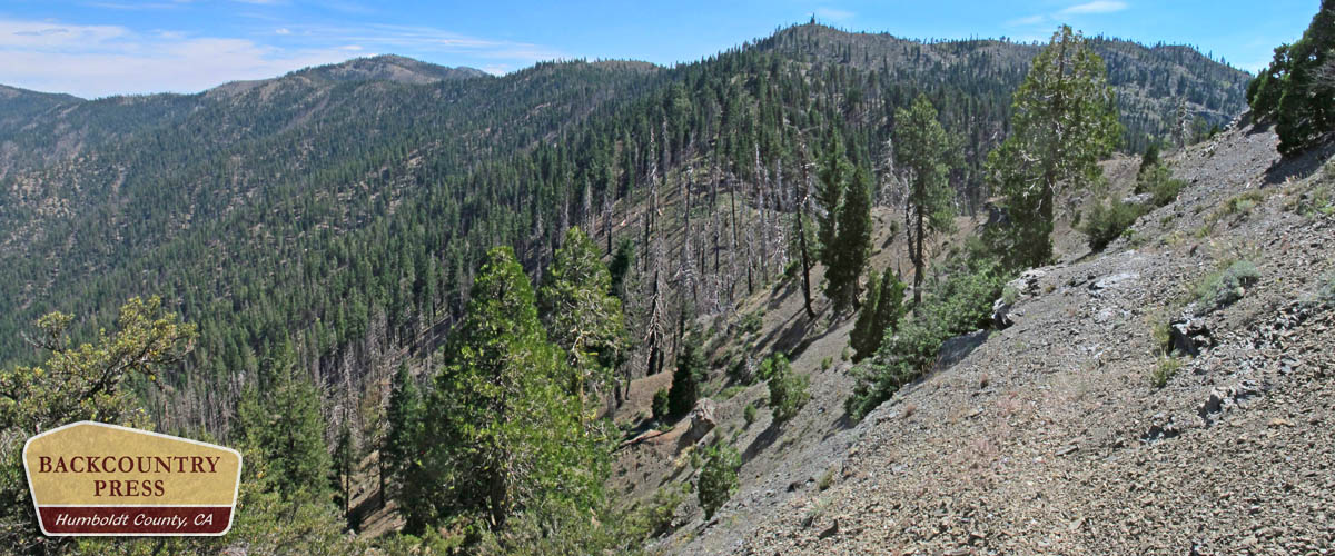
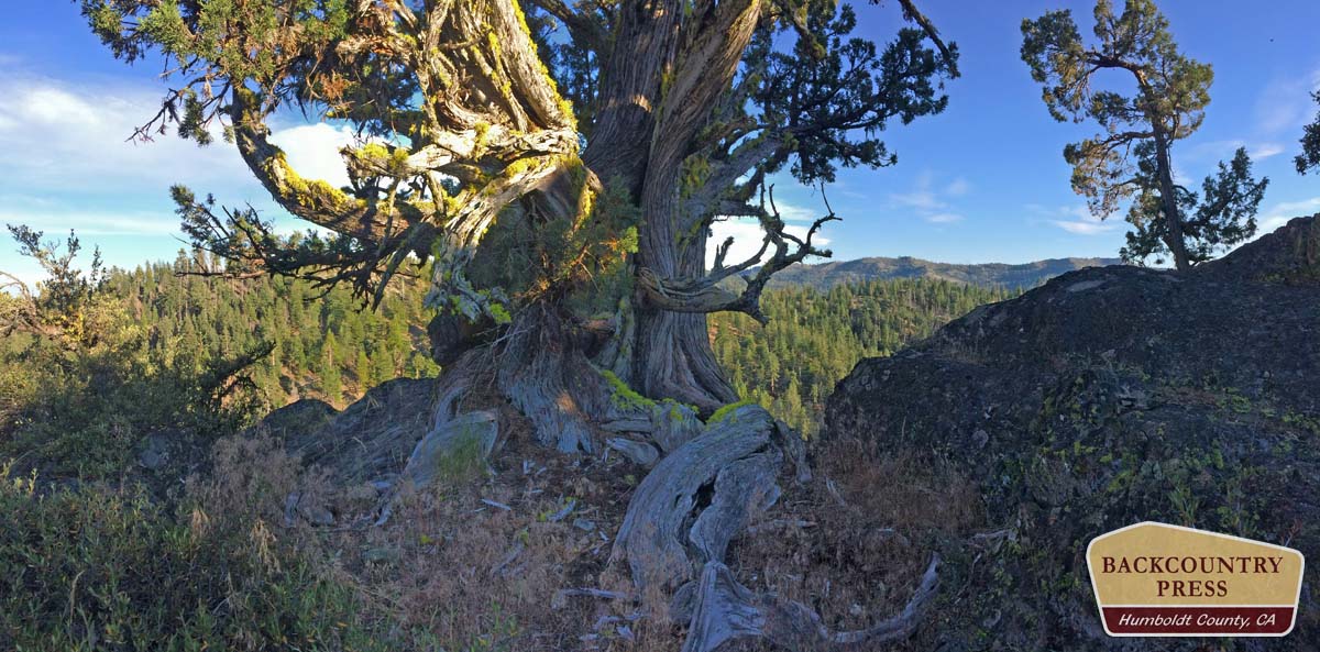
Western junipers (Juniperus occidentalis) tell stories of an arid existence with a connection to the Great Basin. Foxtail pines (Pinus balfouriana) reflect an ancient connection to the Sierra Nevada. Western white pines (Pinus monticola) and quaking aspen (Populus tremuloides) echo the tales of plant migrations between the Klamath and Rocky mountains. Were these species more common here long ago to have become rare with climatic changes? Are some becoming more common as our climate warms? Have the white firs and Douglas-firs dominated the cool, moist north-facing glades longer? How long has fire played a part in the ponderosa and Jeffrey pines distribution across the mountain ridges? The following are 5 permutations, algorithmically arranged–linearly juxtaposed–for your visual and biological pleasure.
5. Bigfoot Trail
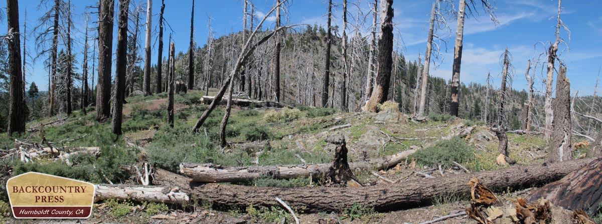
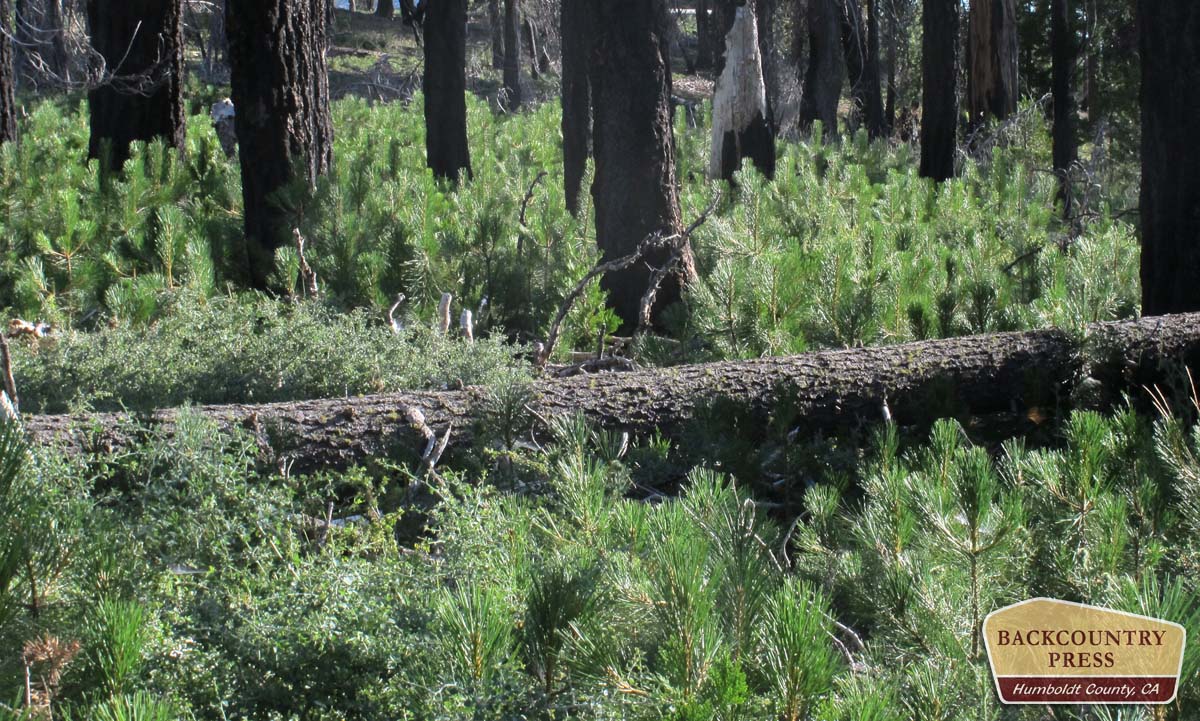
It had been six years since I last walked this stretch of trail. The first time I found myself hear was 10 months removed from a landscape-altering fire. It was more black and white then–with only intact forest and burned forest. In areas where the trail burned, so had the undergrowth. In 2009, it was smooth sailing along the Devil’s Hole Ridge–but not in 2015. Ceanothus, manzanita, and an assortment of bunch grasses have, over 6 years, swarmed the understory in a successional race for dominance. Match-stick conglomerations of downed trees covered sections of trail now, bending and ultimately falling, with winter winds. This made the trail, in several stretches, nearly impossible to find. Another job for the Bigfoot Trail Alliance! But, as I slogged along and sliced my shins, I was thankful for my time here, for my experiences of place, for having experienced this landscape in two dynamic phases.
4. Riparian Canyons
In stark comparison to the dry ridgelines of the north-central Yolla Bolly-Middle Eel Wilderness, there are springs in canyons just below that feed the headwaters of major northwest California rivers like the Mad and Eel. Thank goodness. The springs crossed by the Bigfoot Trail are the headwaters of the Eel River–where they are far enough from humans that their sanctity is intact, unavailable for feeding the green-rush further downstream in the Emerald Triangle. These oases where a-flush with blooming wildflowers fed by verdant streams. Cool glades with names like Frying Pan, Cedar Basin, and Devil’s Hole provided hydration and shade–time for me to go crazy in peace.
3. Western Junipers
Ah, yes. That little slice of the Great Basin in the Coast Range. I originally collected specimens and mapped some of these isolated populations in the fall of 2009, after hiking the BFT and “discovering” range extensions here. Originally described from the southern part of the wilderness on Soldier Ridge, it appears the range is more extensive–growing on arid rocky slopes all the way to the Eaton Roughs of Humboldt County. Seemingly far-displaced from the population center in the desert to the east. The species flourishes in the North Coast Range on arid, rocky, south-facing ridgelines.–probably brought here millenia ago in the bowels of adventurous Townsend’s solitaires where the perfect poop in the ideal habitat has allowed them to flourish.
2. Fire-return intervals
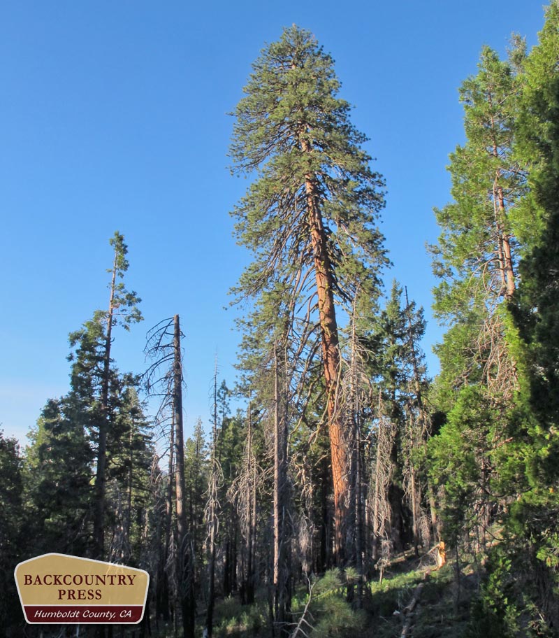
It is clear, after spending any time at all in the Yolla Bolly-Middle Eel Wilderness, that fires play a critical role in shaping the distribution of forest trees and shrubs here. What was most intriguing to me was the relationship between ponderosa pines and the white fir/Douglas-fir/incense-cedar forests. In the Klamath Mountains, white fir/Douglas-fir dominated forests are the most common montane vegetation alliance. But in the Yolla Bolly there are, quite often, ponderosa pines mixed with at least 4 other conifers (also infrequently sugar pine). This is due to a fire regime where, after slow invasions by the firs into the pines habitat, fire ignite and subdues the less fire-tolerant firs allowing, once again, the pines to regain dominance in open, park-like settings.
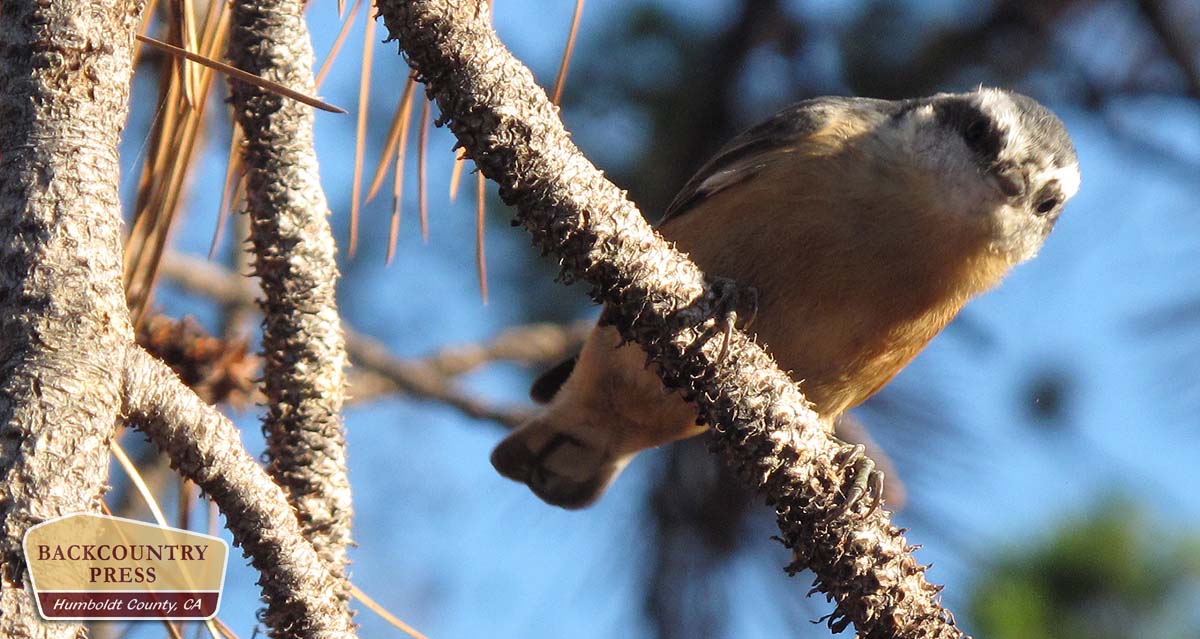
1. I Like Birds
- Check out my list of birds – 56 species in 3 days
I’m a better birder than a botanist. But then again, there are only about 200 bird species I could encounter here and 1,000+ plant species. I find comfort in the birds, probably because I am an animal too. It is easier to understand how we can travel across space and time in a much different manner than a plant. With that comes responsibility, though. We are vectors for good (Townsend’s solitaires could well have originally brought the junipers to the region from the Oregon desert in the recent past) and purveyors of bad (human’s landscape alterations are responsible for the decline of the Olive-sided Flycatcher in western forests).
We are all interconnected and in this way we need wilderness, whether we understand it or not. I wonder when I’ll be able to change the arrangement of daily life and visit the wilds again…I can only hope sooner than later.
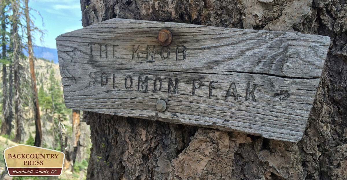
A nice piece of writing on the Yolla Bollys. From 1981 to 1990 I planned and carried out the trail building/maintenance for the SW section of the Yolla Bollys — basically all of the Middle Fork Eel River watershed and the ridges that surround it. In that ten years we brought the trail conditions up to ‘standard’ and re-signed it all — including that ‘The Knob’ sign. A tremendous amount of work was done –resource protection came first (such as preventing erosion and damage to trees), user safety was next (signs, etc), and user-ease came next (widen tread, brushing, etc).
It is sad to see how in the years since, the funding for trail work and wilderness management has failed. Fires have also taken their toll on the trails. But in a way, it is also interesting to see how nature reclaims our attempts to modify it. The decade of walking and working on those trails comes in handy on my backpacks into the Yolla Bollys. Even with that knowledge and experience, it is often necessary to be be able to read the land and the map to make my way.
Blazed trees have fallen from old-age or fire, signs have been torn down by bear or burnt by fire. Brushing the trails was the most constant and tiring jobs we had to do — without it, and without the foot traffic to keep the tread visible, the trails can disappear! It is becoming more like a true wilderness!
I have favorite trees…the twisted juniper on top of Shell Mountain shaded me during last year’s heat spell as I spent 24 hours up on top to celebrate my 60th birthday. On the River Trail there are Dougs of incredible size, and here and there are incense cedars I say hello to when I pass. During my one-week hikes, I rarely see anyone, so one has to say hello to someone!
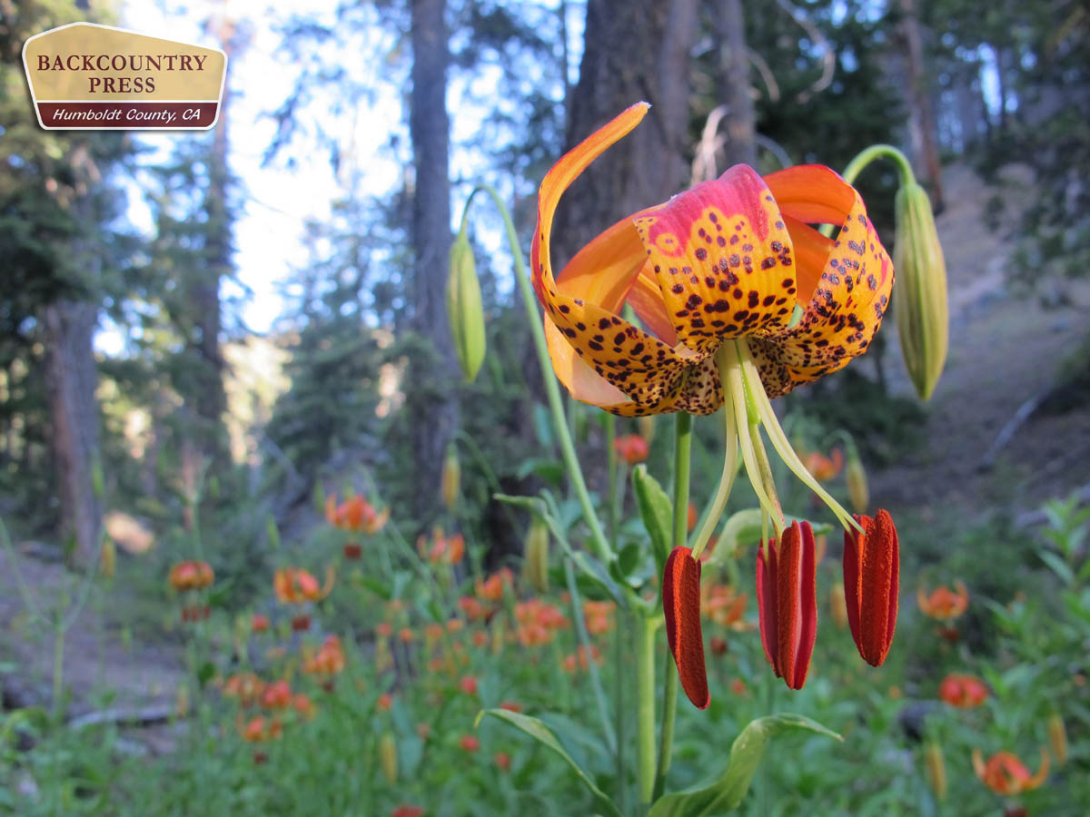
And the Leopard Lillies!!!
The trails are still wonderful and would not be anywhere near as easy to follow if you and others had not done that work in the 80’s and 90’s. I hope to spearhead some brushing and tree clearing on certain sections in the near future–if the forest service does not have plans to do so. It is important to keep these routes open so that they are used by the deer, mountain lion and bear, as well as an occasional human…
I think the bear, lion and deer (oh my!) will always be able to make their way. I had hoped to get my three boys out there to do some volunteer work, but it did not happened – and now they are on their way to college, etc. Let me know if you head out that way to do some work.
The forest service requires certification, including volunteers, to use a misery whip now. Not hard to get, but something one needs to plan for. An axe works fine for the smaller stuff, but the bigger stuff is a different story. Brushing is great for upper body strengthening!
In the past the forest service would get a CCC or Americorps (sp?) group into the wilderness to do some work. Unfortunately, some of the skills and knowledge of trail work has been lost. I saw some of their work on the Soldier Ridge Trail a couple years ago. Some was great, but their waterbars were useless…bad design. It was sad to see all that time and effort gone to waste due to bad design — the waterbars would have failed before the end of the summer/fall, let alone protect the trail from the winter rains and spring run-off.
Brushing is tiring work and should clear a 6′ to 8′ path. Otherwise, one does a lot of work only to have the brush come back over the trail within a couple years. The general trailwork philosophy is that any work one does should be done in a lasting way. Waterbars need to be located and made so that they are self-cleaning or need minimum maintenance…it is rewarding to see waterbars I put in 30 years ago still working.
I am verbally rambling now. Go wild!
On my week-long treks into the Yolla Bollys, I do not keep to a plan — I more-or-less wander, much more interested in being there than in getting somewhere.
I had thought to have a dry camp on Sugarloaf Peak (near The Knob) after my hike-in from Soldier Ridge TH and an over-night stop at Minnie Lake (a small pond, really, but the coldest and most wonderful spring I found yet). But something told me to spend a second night at Minnie Lake and to explore the interesting land forms there.
Soon after this decision, I was rewarded, and my decision obviously approved of, by the appearance of a flying square of fur landing 6 feet in front of me on a trunk (and about 6′ up from the ground) in my campsite. This flying square transformed itself into a squirrel that checked me out before climbing the tree.
Later on the trip I was again rewarded with the discovery of a small pond I had heard about, but never had found. Snow and spring fed, this delightful little alpine pond was close to the ridge top and was back-dropped by huge blocks of white chert that had tumbled off the ridge. The distant view was of South Yolla Bolly Mountain but if the air was clear, perhaps Lassen would have been there somewhere.
This was the same area where we were doing trail work in the middle of a-long-time-ago July and the crew and I were suddenly in white-out conditions — snow coming down hard, with lightning hitting the ridge top just a hundred feet above us. Fortunately, I had sent a few crew members ahead with the mules to our next camp and they were all settled down before the storm it. The storm cleared before sunset and the snow line was only a hundred feet below us — and all gone by mid-day the next day. But sleeping on snow in the Yolla Bollys in mid-July!!! This is why I love the wilderness!
Great memories, thanks for sharing Vaughn!
Yes, thanks for sharing. I enjoyed it.
I too enjoyed Michael’s writing and Vaughn’s long knowledge of the place. Tomorrow I go in the north end from Stuart Gap to look for the type locality of Hosackia (formerly Lotus) yollabolliensis on the ridgetops around Black Rock. I am beyond grateful to have mules to carry my plant presses and packer Ken Graves to share his long experience there.
Thanks Julie- I’d love to see some pictures of the Hosakia when you return, is it only on Blackrock Mountain? Have a great trip and enjoy the views!
I worked with Kenny in the bollas almost 20 years ago what a great man I have recently started teking back to some of the trails we improved it saddens me to see the condition of the trails I would love to lead a crew back in to the bollas and start improving the trails put up new sings but fix trail heads but there is no money
Thanks for sharing Josh. I’m working to get some money and improve the trails! http://bfta.bigfoottrail.org/